18060 Monterey Road
Offering · Development site · Morgan Hill, California
Corridor development site · Morgan Hill

18060
Monterey Rd.

A level 0.88-acre parcel on the Monterey Corridor Form-Based Code, between Monterey Road and the Caltrain line. The zoning allows townhomes, multifamily and mixed use.

Price
$3.25M
$84.64 / sf of land
Lot
38,400sf
0.88 ac · ~120 × 315–330 ft
Zoning
FB-C
Corridor Form-Based · 45 ft
Image: drone photograph over Monterey Road, October 2026, looking north-northeast. The lot runs from the corner landscape bed back to the rail line.
01 The Parcel

A deep, level lot on Monterey Road.

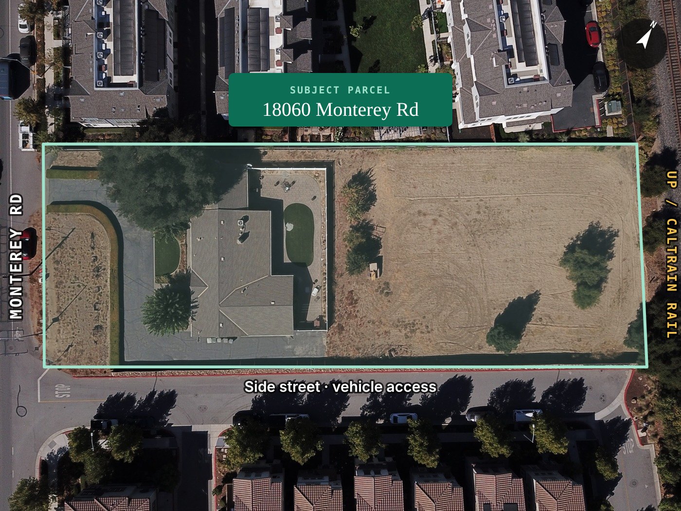
An approximately rectangular lot with about 120 feet on Monterey Road, running 315 to 330 feet back to the Union Pacific and Caltrain corridor. Today it holds a 2,128-square-foot home from 1969 and open land behind it. The lot's depth is what allows several different site layouts.

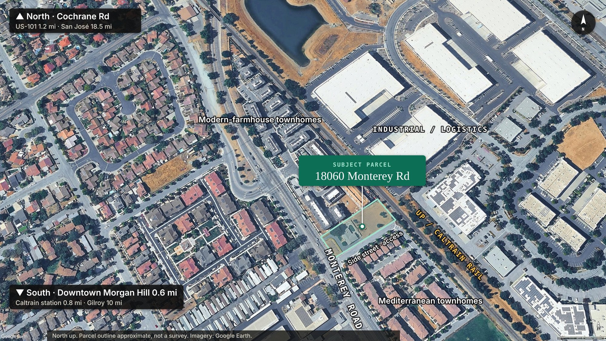
October 2026 drone photograph straight down over 18060 Monterey Road with the approximate parcel boundary outlined in mint, Monterey Road at left, the rail line at right and the side street below
Drone aerial · October 2026 · APN 726-25-00538,400 sf · 120 ft frontage
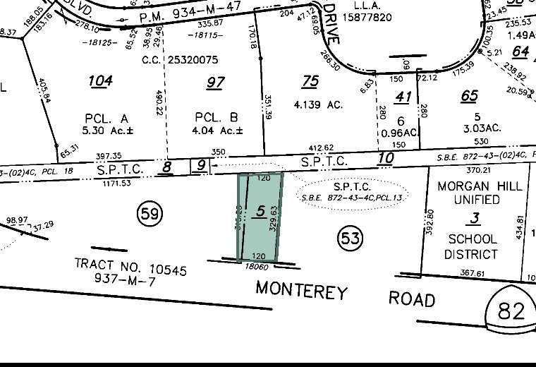
Lot lines · Book 726, Page 25Santa Clara County Assessor
Detail of Santa Clara County assessor's map Book 726 Page 25 with parcel 5 highlighted

Parcel 5 fronts Monterey Road and backs onto the S.P.T.C. railroad right-of-way. The assessor map records 120 ft at each end and side lines of 315.20 and 329.63 ft. North is not at the top of this sheet.

APN
726-25-005
Address
18060 Monterey Road
Morgan Hill, CA 95037
Lot area
38,400 sf / 0.88 acreAssessor record · County GIS polygon ≈ 37,657 sf · survey controls
Zoning
FB-C (Corridor Form-Based)Per City zoning map · PD overlay to confirm
Code
Monterey Corridor Form-Based Code
Ch. 18.29 · Ordinance 2348 (2023)
Max height
45 ft / FB-C district
Frontage
~120 ft on Monterey Road
Rear line on the rail right-of-way
Flood zone
FEMA Zone X (shaded) — 0.2% annual-chance flood hazard area (500-year floodplain)FEMA Map Panel 06085C0443H · effective May 18, 2009
Existing use
Single-family home · 2,128 sf, built 19693 bed · 2.5 bath · 624 sf garage · pool & spa
Assessed (2026)
$1,397,400 totalland $1,071,000 · improvements $326,400
Terms
MLS #82031201 & #82032799
Listed January 2026 · Exclusive Right to Sell
Legal description, easements and the access rights for the side roadway come from the preliminary title report, available to qualified buyers with the offering memorandum.
Utilities & site conditions

Public water and sewer serve the existing home.

The MLS records public water, public sewer and public utilities serving the existing home. Existing service doesn't establish capacity for a larger project. Will-serve letters and a capacity check are the usual first steps.

Electric
PG&E delivery · Silicon Valley Clean Energy generation
Gas
PG&E territory · service at site to be verified
Water
City of Morgan Hill · public, at site
Sewer
City of Morgan Hill · treatment by South County Regional Wastewater Authority
Stormwater
City requirements · to be confirmed with Public Works
Telecom
Provider coverage · to be confirmed
Topography
Level
Flood
Zone X (shaded)
Fault zone
None mapped

FEMA Zone X (shaded), the 0.2% annual-chance flood hazard area (500-year floodplain), on Panel 06085C0443H, effective May 18, 2009. The property is outside the mapped 1% annual-chance Special Flood Hazard Area on this panel. Flood designations are based on FEMA mapping and are subject to subsequent map revisions and site-specific verification. The parcel does not intersect the County's Alquist-Priolo fault-zone layer; that is a screen, not a geotechnical clearance.

⚠
Diligence items. No Phase I Environmental Site Assessment, survey or geotechnical report has been provided. The rear line abuts an active rail corridor, so residential designs should plan for noise and vibration. Redevelopment would remove the 1969 home, pool and spa. The property is shown by drive-by only; please do not disturb the occupants.
02 Aerial tour

See the site from the air.

Drone video and photography of the parcel, the Monterey Road frontage and the rail edge, captured for this listing. Showings are drive-by only.

Drone flyover

03 Zoning & approval routes

Form-based zoning that allows housing.

The City's 2023 Monterey Corridor Form-Based Code regulates building form and street frontage more than use. In the FB-C district, multifamily, townhouse, live/work and mixed-use residential are permitted uses. A buyer chooses the approval route that fits the program.

01
Form-based review · local

FB-C Corridor Form-Based

Uses marked "P" in Table 18.29-2 need no use permit, including multifamily, attached single-family, live/work and mixed-use residential. Projects go through the City's design and building permit review under Chapters 18.104 and 18.108. A Planned Development overlay is mapped in the area; its ordinance and conditions are being confirmed with the City.

Use permitNot required (P uses)
Height45 ft
Coverage75% max
02
State housing law

SB 330 + State Density Bonus

An SB 330 preliminary application for a housing project can hold the standards and fees in effect when it is submitted, provided the full application follows within 180 days and the project is not substantially changed; it does not approve the project. A project that includes affordable units can use the State Density Bonus Law for more units and for concessions or waivers of standards such as height. Nearby, the City approved the 66-unit affordable Magnolias project at 59 ft with a waiver.

Preliminary application$1,438.80 limited review
BonusPer affordability
Base densityStudy required
03
Potential additional pathways · eligibility unconfirmed

SB 35 / SB 423 · AB 2011

These statutes offer ministerial approval for qualifying housing, with affordability, labor and site criteria. Eligibility for this parcel, and the City's current state determination, have not been established and require review by land use counsel. The parcel did not intersect MTC's SB 79 transit zones as of October 5, 2026.

StatusNot an available entitlement
EligibilityUnconfirmed
ReviewLand use counsel
Dimensional standards · FB-C

Summary of Chapter 18.29, § 18.29.030, and not a substitute for the code. Rely on the City's written zoning determination. *Street-side standards apply only if the side roadway is legally a street; its status is unconfirmed.

StandardFB-C (subject)FB-N, for referenceFB-UG, for reference
Max height45 ft35 ft (40 ft vertical mixed use)55 ft
Lot coverage75% max75% max80% max
Front setback0–15 ft build-to5–15 ft5–25 ft
Street side0–15 ft · 40% min. build-to*——
Side / rear0 ft interior · 10 ft rear5 ft · 15 ft0 ft · 20 ft
Build-to80% of front70%65%
Upper floors8 ft stepback at 3rd story+—8 ft stepback at 3rd story+
Parking40 ft min. from front30 ft from front40 ft from front
Zoning verification
A written zoning designation letter is available from the City of Morgan Hill Planning Division; the published fee is $960. The City's form-based code page lists Principal Planner Adam Paszkowski, 408-310-4635. Ask the City to confirm the district, the PD overlay and its conditions, and the General Plan designation.
The envelope from above

An overhead drone view of the parcel, Monterey Road at the top and the rail line at the bottom, with the FB-C front build-to zone and rear setback drawn on.

How to read it
The front 0–15 ft zone on Monterey Road is where FB-C requires 80% of the building face. The rear 10 ft along the rail line is the minimum setback. Lines are approximate and drawn on imagery; a boundary survey controls.
⚠
Independent verification recommended. The routes above summarize current law. Eligibility, standards, required parking under Chapter 18.72, and affordable-housing obligations (15% for for-sale projects outside downtown) require confirmation with the City and land use counsel.
04 Development paths

Six conceptual development approaches, in 3D.

Walk the lot as it is today, then switch between six conceptual approaches: townhomes, stacked residences, courtyard housing, smaller mixed use, a mixed-use podium, and affordable or senior housing. They are conceptual scenarios that illustrate potential uses and architectural character. They do not establish approved unit counts, building envelopes or entitlements; overlays, General Plan requirements, density, parking and access require confirmation with the City.

How to exploreOpen full screen ↗
  1. Pick a path. Use the numbered tabs at the top left of the model, or the path cards below, to switch between today's site and the six concepts.
  2. Move around. Drag to rotate, scroll or pinch to zoom, and right-drag (two fingers on a phone) to move. Open full screen for preset views from the street, the rail side or straight down.
  3. Change the look. Design style switches every building between California modern, Modern farmhouse and Mediterranean. Sun moves the shadows by season and time of day.
  4. Check the rules. Under Layers, turn on 45 ft limit, FB-C setbacks or Neighbor heights to compare each path with the zoning envelope and the townhomes on either side. Parking counts shows stalls provided against stalls required.

Illustrative study, not an approved project. Massing and all three design styles are illustrative, not an architectural design or a representation of any approved or approvable project. Imagery: drone orthomosaic captured October 19, 2026 around the site, blended into 2024 Santa Clara County orthoimagery beyond the drone coverage. Parcel line from Santa Clara County GIS, not a survey. Neighboring buildings modeled from October 2026 drone imagery; footprints and heights approximate.

All development illustrations are conceptual. Rendered structures, unit counts, heights and layouts may differ from what can ultimately be permitted or built; buyers should verify feasibility with the City of Morgan Hill and qualified consultants. The massing, styling, unit counts and site layouts are not architectural designs, engineered plans, or representations of any approved or approvable project. Actual development requires design, engineering and municipal approvals. Imagery: October 2026 drone orthomosaic blended into 2024 Santa Clara County orthoimagery; parcel line from County GIS, not a survey.

05 The Corridor

On Monterey Road, north of downtown.

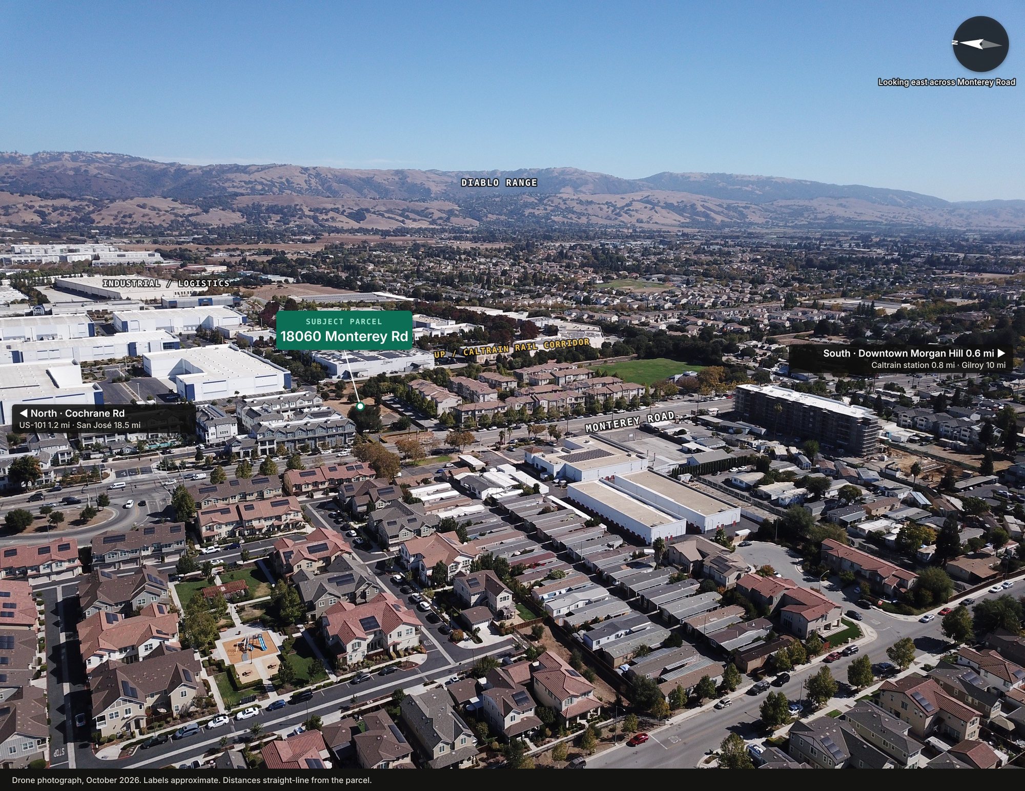
The site sits in the stretch of Monterey Road that the City rezoned in 2023 for walkable, mixed-use frontage. Downtown Morgan Hill is about 0.6 mile south and the Caltrain station about 0.8 mile; townhome and condominium projects are under way to the north toward Cochrane Road.

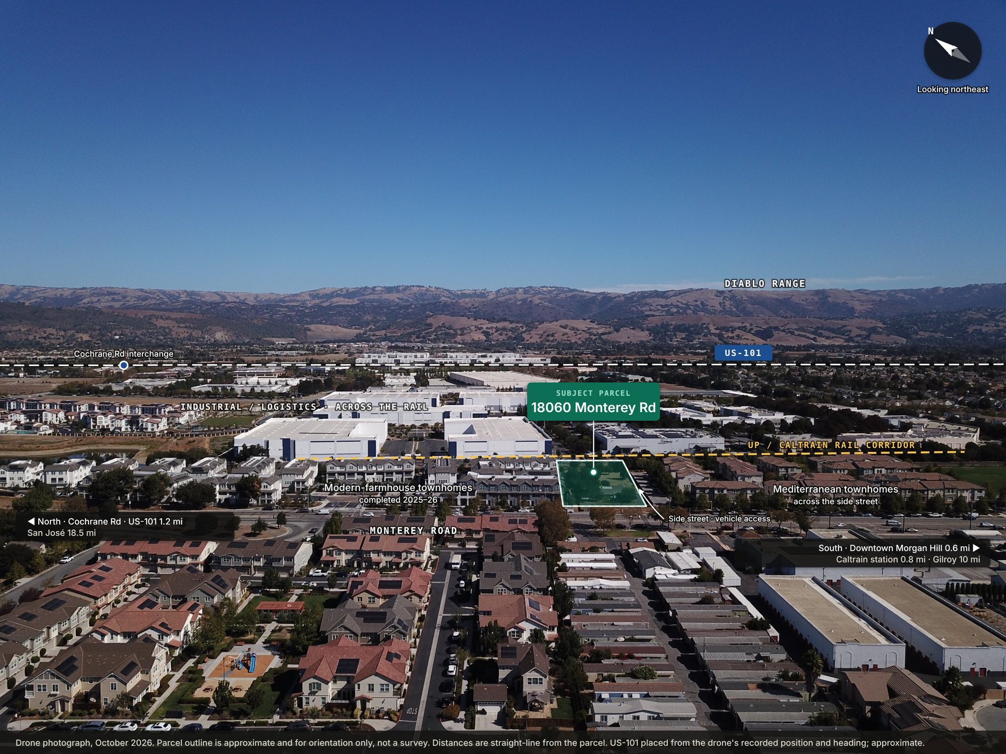
October 2026 drone photograph looking east across Monterey Road, with 18060 Monterey Road labeled between the townhome communities, the rail corridor and industrial district behind, and directions north to Cochrane Road and south to downtown Morgan Hill and Caltrain

October 2026 drone photograph, looking east. The parcel fronts Monterey Road on its southwest side and backs onto the Union Pacific and Caltrain right-of-way on its northeast side. Labels are approximate; select the image to open it full size.

Nearby

Distances from the property, as published in CoreLogic and MLSListings records, or measured straight-line.

01 · TransitMorgan Hill Caltrain station0.8miStraight-line · 17300 Depot St
02 · SchoolLewis H. Britton Middle School0.5miMiddle school
03 · SchoolEl Toro Health Science Academy0.6miK–5
04 · RetailWalmart · Cochrane Plaza0.8miPer CoreLogic
05 · SchoolLive Oak High School1.5miHigh school
06 · SchoolAnn Sobrato High School1.5miHigh school

Average daily traffic on Monterey Road

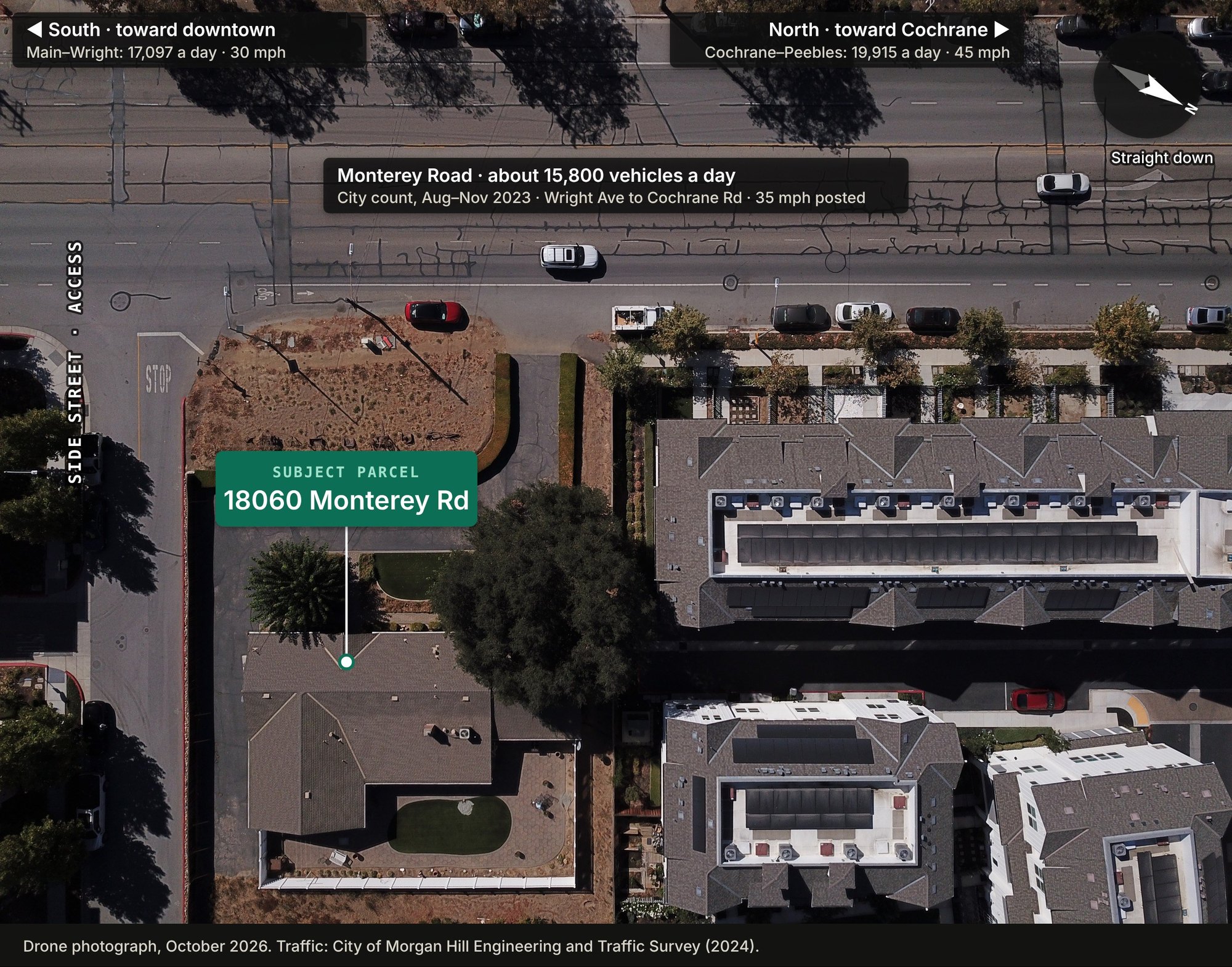
About 15,800 vehicles pass the frontage on an average day. The subject sits in the Wright Avenue to Cochrane Road segment. City of Morgan Hill tube counts, August to November 2023, listed south to north.

Drone photograph straight down over the Monterey Road frontage of 18060 Monterey Road, labeled with about 15,800 vehicles a day, 35 mph posted, and the counts on the segments to the south and north
Dunne Ave – Main Ave · 25 mph
17,257
Main Ave – Wright Ave · 30 mph
17,097
Wright Ave – Cochrane Rd · subject · 35 mph
15,822
Cochrane Rd – Peebles Ave · 45 mph
19,915
Peebles Ave – city limit · 50 mph
19,073

Source: City of Morgan Hill Engineering and Traffic Survey (signed May 6, 2024), Table 2, segments 69–73; posted speeds from the same survey.

06 The Area

Morgan Hill and the South Bay.

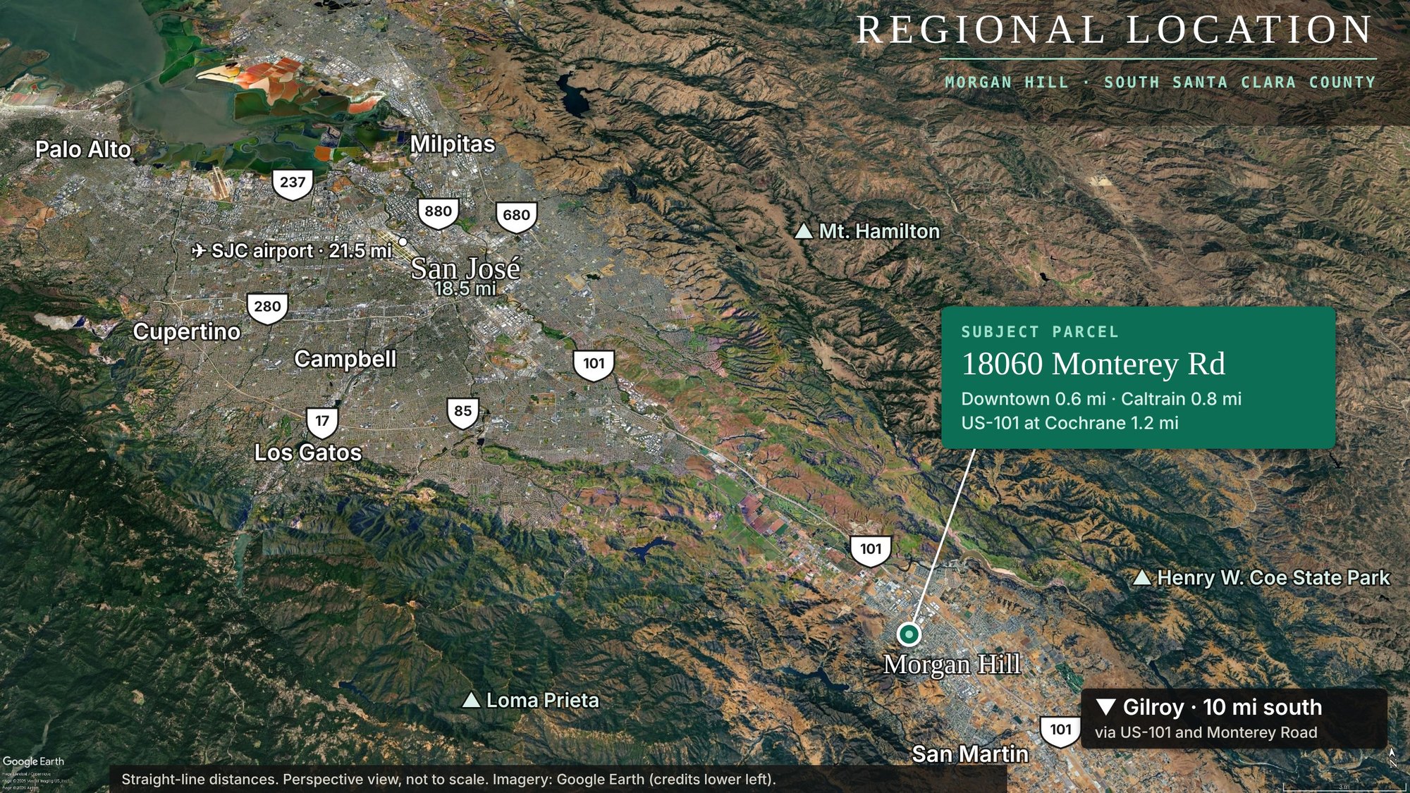
Morgan Hill sits on US-101 at the southern edge of the Santa Clara Valley. The area around the site has a white-collar workforce, average household incomes near $158,000, and mostly owner-occupied housing.

Drone photograph looking northeast across Monterey Road with the parcel outlined between the modern-farmhouse townhomes and the Mediterranean townhomes, the rail corridor and industrial district behind, the Diablo Range beyond, and arrows toward Cochrane Road to the north and downtown Morgan Hill and Caltrain to the south

October 2026 drone photograph, looking northeast. Parcel outline is approximate and for orientation only, not a survey. Distances are straight-line from the parcel. Select the image to open it full size.

Population
51,517
+9.8% since 2010
Households
16,512
69.2% owner-occupied
Avg household income
$158.3K
$66,417 per capita
White-collar share
84%
34 min median commute
Demographic profileCoreLogic · October 2026
Population
Estimated population51,517
Median age39.1
Growth since 20109.8%
Bachelor's degree12,290
Graduate degree5,531
Households & housing
Households16,512
Average household size3
Owner-occupied69.2%
Median home sale price$1,152,400
Median year built1987
Annual turnover10.4%
Workforce & commute
White collar84.0%
Services employment8,055
Manufacturing3,771
Median travel time34 min
Drive to work77.2%
Work from home19.1%

Figures cover the area CoreLogic associates with the address (CoreLogic Neighborhood Profile, October 2026); white-collar share is CoreLogic's occupation classification of employed residents. Census-tract estimates may differ.

Schools nearby
Lewis H. Britton Middle School0.5 mi
El Toro Health Science Academy0.6 mi · K–5
P. A. Walsh STEAM Academy0.8 mi · K–5
Live Oak High School1.5 mi
Ann Sobrato High School1.5 mi

Morgan Hill Unified School District. Distances per CoreLogic and MLSListings; confirm school assignment with the district.

Transit & access
RailCaltrain at Morgan Hill station, 17300 Depot Street, about 0.8 mi south
BusVTA routes connect at the station, including Rapid 568
RoadMonterey Road runs parallel to US-101 as the local alternative to the freeway

Sources: CoreLogic Neighborhood Profile and Property Details (October 2026) · MLSListings · City of Morgan Hill 2023 Engineering and Traffic Survey · City of Morgan Hill ordinances 2344 and 2348 · Santa Clara County Assessor and GIS.

07 Site factors & diligence

What's known and what to verify.

The zoning, parcel and hazard factors that shape any project here, with how firmly each one is known today. Medium and low items are the ones to resolve before an offer or an application.

Regulatory & site snapshot

Confidence reflects the public information reviewed for this listing, not a legal or engineering opinion.

High · documentedMedium · confirmLow · verify before relying
FactorWhat we knowConfidence
Zoning & approvals
Zoning districtFB-C Corridor Form-Based, per the City zoning map. A written determination has been requested.Medium · confirm in writing
PD overlayA Planned Development overlay is mapped in the area; whether it covers this parcel, and its conditions, are unknown.Low · verify
General PlanThe 2035 General Plan applies Mixed Use Flex mainly along Monterey Road. Parcel designation and any density cap not confirmed.Low · verify
Height & coverage45 ft maximum, 75% lot coverage, 0–15 ft front build-to zone, 10 ft rear setback, 8 ft stepback at the 3rd story. Code text is confirmed; whether these standards apply unmodified to this parcel depends on the PD overlay.High (code) · Medium (parcel)
Inclusionary housing15% of for-sale units outside downtown; fractions below a whole unit pay a fee. Alternatives and in-lieu elections may apply; rental projects are evaluated separately.High · City code
Parcel
Lot size38,400 sf per the assessor; County GIS measures about 37,657 sf. A boundary survey controls.Medium · survey
Side-street accessListing remarks reference an existing roadway on the south side. Width, ownership and access rights not confirmed. Driveways shown on that roadway in the 3D studies are illustrative, not a confirmed access route.Low · title review
Large corner treeA mature tree near the Monterey corner. Removal may need a City tree permit.Medium · arborist
Existing improvements1969 home, pool and spa. A hazardous-materials survey is typical before demolition.Medium · inspect
ParkingChapter 18.72 applies: townhomes 2 covered per home; multifamily 1 covered (studio/1-BR) to 1 covered + 1.5 (3-BR); guest 1 per 4 homes; retail about 1 per 250 sf. The half-mile transit waiver likely does not apply (Caltrain about 0.8 mi). Parking, not the building envelope, limits unit counts on this 120-ft-wide lot: as modeled, Path 1 meets its 52 spaces with 53; Paths 2 and 4 are sized to their surface lots; Path 3 needs a podium garage; Path 5 relies on lifts and density bonus ratios.Medium · confirm ratios
Access & fireAll vehicle access is modeled from the side street, none from Monterey; residential driveways must be at least 18 ft wide for two-way traffic (Table 18.72-4). Surface lots in Paths 1, 2, 4 and 6 use two driveways so aisles loop instead of dead-ending; under California Fire Code Appendix D, a fire-access dead end over 150 ft needs a turnaround. Buildings over 30 ft need a 26-ft aerial access road 15–30 ft from one full side, which the side street and Monterey may satisfy. Whether the side roadway is a public street, and its width, are unconfirmed and control all of this.Low · fire marshal & title review
UtilitiesPublic water and sewer at the site. Capacity for a multi-unit project, fire flow and electrical service not confirmed.Medium · will-serve
Hazards
Flood zoneFEMA Zone X (shaded), 0.2% annual-chance flood hazard area (500-year floodplain); Panel 06085C0443H, effective May 18, 2009. Outside the mapped 1% annual-chance Special Flood Hazard Area on this panel; subject to map revisions and site-specific verification.High · FEMA map
Earthquake fault zoneNo intersection with the County Alquist-Priolo fault-zone layer. A screen only, not geotechnical clearance.Medium · screen
Liquefaction & soilsNot screened for this page. Covered by the Natural Hazard Disclosure report; a geotechnical report sets foundation design.Low · see NHD report
Fire hazard zoneNot screened for this page. The City adopted updated fire hazard severity maps in 2025; the NHD report states the designation.Low · see NHD report
Rail noise & vibrationThe rear line abuts the active Union Pacific / Caltrain line. Residential design needs a noise and vibration study.High · known condition
Historic resourceNot screened. The existing 1969 home is past the 45-year age often used in historic review.Low · verify
✓ Known · public record & listing

What the record shows

  • Address & parcel18060 Monterey Rd, Morgan Hill, CA 95037 · APN 726-25-005 · Santa Clara County
  • Lot38,400 sf (0.88 ac) · about 120 ft on Monterey Road × 315–330 ft deep
  • ZoningFB-C Corridor Form-Based Code (Ordinance 2348, 2023) per the City map
  • Existing home2,128 sf single-family residence built 1969, with pool and spa
  • UtilitiesPublic water and sewer at the site
  • FloodFEMA Zone X (shaded) · 0.2% annual-chance (500-year) floodplain · Panel 06085C0443H, effective May 18, 2009
  • Rear lineUnion Pacific / Caltrain railroad right-of-way
  • NeighborsThree-story townhome communities on both sides, completed by October 2026
? To verify · site-specific diligence

What a buyer should confirm

  • Written zoning determinationDistrict, PD overlay and its conditions, General Plan designation and any density cap
  • Boundary surveyExact lot area and dimensions; assessor and GIS differ by about 2%
  • Title reportRecorded access rights to the side roadway; easements of record
  • Natural Hazard Disclosure & geotechnicalLiquefaction, soils, fire hazard zone, seismic design
  • Arborist reportThe large corner tree and any protected trees
  • Noise & vibration studyRail-side unit design and window ratings
  • Utility will-serveWater, sewer, fire flow and electrical capacity for the chosen program
  • Phase I & demolition surveyEnvironmental history; hazardous building materials in the 1969 home
08 From concept to approval

How a project gets approved.

The usual approval steps for each kind of path, and the terms used on this site.

Paths 1 through 4

Within FB-C standards

Townhomes or multifamily designed to the 45 ft limit and the form-based standards, subject to parcel-specific confirmation.

  1. Zoning letter & pre-application meetingWritten determination (published fee $960); early consultation with Planning is recommended.
  2. Survey, test fit & SB 330 preliminary applicationCan hold standards and fees if deadlines are met; requires site plan, elevations and a tentative map.
  3. Full application & completenessDue within 180 days of the preliminary application; the City reviews completeness.
  4. Design review, tentative map & CEQADecision on design and the subdivision map; state law caps hearings for code-compliant housing.
  5. Final map & building permitsImprovement plans, final map recordation, plan check.
Paths 5 and 6

Density bonus or height waiver

Projects above 45 ft or above base density, using affordable units under state law.

  1. Zoning letter & base-density studyBase density sets the bonus; General Plan density matters here.
  2. Affordability plan & preliminary applicationAffordable unit count, waivers and concessions requested.
  3. Full application & completenessDensity bonus report and affordable housing agreement terms.
  4. Review & approvalLonger review for height waivers; 100% affordable projects may qualify for ministerial routes.
  5. Funding, final map & permitsFor affordable projects, tax-credit and subsidy cycles often set the pace.

These sequences are illustrative, not City-published timelines; actual timing depends on the project, staff workload and any appeals. The 180-day window from preliminary to full SB 330 application, the $960 zoning letter fee and the $1,438.80 limited-review preliminary application fee are from City of Morgan Hill sources and should be confirmed against the current fee schedule.

A quick visual glossary

FB-C · Form-based code

Rules that control a building's size, placement and street face rather than separating uses. FB-C is the corridor district, with a 45 ft height limit.

Build-to zone

The strip along the street, 0–15 ft deep in FB-C, where the building face must sit. 80% of the frontage must be built in it.

Stepback

An upper floor set back from the floor below. FB-C requires 8 ft at the third story and above, so tall walls don't sit right on the street.

PD overlay

A Planned Development layer on top of the base zoning that can add site-specific conditions. One is mapped in this area; its effect here is unconfirmed.

SB 330 preliminary application

A short state-law filing for a housing project that can hold the standards and fees in effect when it is filed, if the full application follows within 180 days and the project is not substantially changed. It does not approve the project.

State Density Bonus

State law that allows more homes, and waivers or concessions such as extra height, when a project includes affordable units.

Inclusionary housing

Morgan Hill requires 15% of for-sale homes outside downtown to be affordable. For 23 townhomes, 15% is 3.45 units: three affordable units plus an in-lieu fee for the fraction. Alternatives may apply; rental projects are treated separately.

Frontage type

How a ground floor meets the street, such as shopfront, stoop or forecourt. Each FB-C street frontage needs at least one listed type.

09 Next step

Documents for qualified buyers.

The offering memorandum, architect site studies, Natural Hazard Disclosure and preliminary title materials are available to qualified buyers. Please contact your real estate professional for access. Showings are drive-by only; please do not enter the lot.
Sources

Records and reports used on this site.

The records, codes and reports behind the figures on this site, with access dates.

  1. MLSListings / MetroList listing reports, ML82031201 and ML82032799, as of October 14, 2026; mlslistings.com/property/ML82032799.
  2. CoreLogic Property Details report, 18060 Monterey Rd, APN 726-25-005, generated October 15, 2026 (assessment, tax, characteristics, transfers, rental estimate, flood).
  3. Santa Clara County Assessor, Assessor's Map Book 726 Page 25, effective roll year 2024–2025.
  4. CoreLogic Neighborhood Profile, 18060 Monterey Rd, generated October 15, 2026 (demographics, schools, businesses within one mile).
  5. Morgan Hill Municipal Code Chapter 18.29, Monterey Corridor Form-Based Code, §§ 18.29.020–.090; codified text, accessed October 14, 2026.
  6. City of Morgan Hill Ordinance No. 2348, Monterey Corridor Form-Based Code; morganhill.ca.gov, accessed October 14, 2026.
  7. City of Morgan Hill, Monterey Corridor Form-Based Code project page; morganhill.ca.gov/2060, accessed October 14, 2026.
  8. City of Morgan Hill, 2023 Engineering and Traffic Survey (signed May 6, 2024), segments 69–73; morganhill.ca.gov, accessed October 14, 2026.
  9. Morgan Hill station, 17300 Depot Street (37.12944, −121.65056), Caltrain on the UP Coast Subdivision; Wikipedia, accessed October 14, 2026.
  10. "Monterey Road," Wikipedia, accessed October 14, 2026.
  11. City of Morgan Hill, Monterey Corridor Block-Level Master Plan page; morganhill.ca.gov/1727, accessed October 14, 2026.
  12. City of Morgan Hill, Sewer Division; morganhill.ca.gov/589, accessed October 14, 2026.
  13. "Clean energy program starts in April," Morgan Hill Times, February 6, 2017; morganhilltimes.com.
  14. City of Morgan Hill Ordinance No. 2344 and Resolution No. 23-006 (The Gates); morganhill.ca.gov, accessed October 14, 2026.
  15. MLSListings, ML82058042 (25 Peebles Ave), ML82019675 (0 Monterey Rd), ML82042145 (220 W Edmundson Ave), accessed October 14, 2026.
  16. "Properties on the move from commercial to residential," Morgan Hill Times, September 23, 2022; morganhilltimes.com.
  17. Independent desktop development review, "18060 Monterey Road: Development possibilities, constraints, and alternatives," October 5, 2026. Its sources include the City of Morgan Hill zoning map (effective Oct. 6, 2023), Ordinance 2348 Exhibits A/B, Santa Clara County parcel GIS (layer 116) and hazard layers (101, 112), the MTC SB 79 map, HCD and ABAG housing-law guidance, Morgan Hill Title 14 and the 2026 inclusionary price table, the City impact-fee worksheet (July 1, 2026) and planning fee schedule (FY 2026–27), and City project pages for The Gates and Magnolias, all accessed October 5, 2026.
  18. City of Morgan Hill, Housing Development Under SB 330; morganhill.ca.gov/2099, accessed October 20, 2026.
  19. City of Morgan Hill, Fire Hazard Severity Zones Maps; morganhill.ca.gov/2617, accessed October 20, 2026.
  20. FEMA Flood Map Service Center, panel 06085C0443H; msc.fema.gov.
  21. Drone photography and video of the site, captured October 19, 2026, for this listing.